


Mappt
GIS Data Collection
Mappt: GIS Data Collection ၏ ရွင္းလင္းခ်က္
Mappt ™အသုံးပြုသူများကိုတဦးတည်းအလင်း, ကျစ်လစ်သိပ်သည်းကိရိယာနှင့်အတူ, ပြင်ဆင်ရန်, စတိုးဆိုင်နှင့်ရှယ်ယာတည်နေရာ-based data တွေကိုဖန်တီးခွင့်ပြုတဲ့အင်အားကြီး GIS (Geographic Information System) ဒေတာစုဆောင်းခြင်း App ဖြစ်ပါတယ်။
Mappt ™သဘာဝပတ်ဝန်းကျင်နှင့်စိုက်ပျိုးရေးကနေကမ္ဘာတစ်ဝှမ်းတွင် 130 ကျော်နိုင်ငံများရှိသတ္တုတွင်းနှင့်ဒေသခံအစိုးရမှ spanning စက်မှုလုပ်ငန်းများအတွက်အသုံးပြုသည်။
ဒါဟာအပါအဝင် ArcGIS နှင့် QGIS, ပင်လယ်ပြင်အချက်အလက်ကောက်ယူမှုအသစ်သောသူတို့အားမိနစ်ကျွမ်းကျင်လိမ့်မည်ဟု features တွေအသုံးပြုရလွယ်ကူအသုံးပြုသူဖော်ရွေ interface ကိုကောင်းကင်ဗိုလ်ခြေအရှင်အပါအဝင်လူကြိုက်များ desktop ကို GIS နဲ့ပေါင်းစပ်ပြီးဘာဖြစ်လို့လဲဆိုတော့သူတို့ဟာ Mappt ™ကိုရှေးခယျြ:
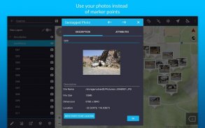
- ပထဝီအချက်ဓါတ်ပုံသင့်ရဲ့အရေးကြီးတဲ့ Data ရုံအမှတ်အသားအချက်ထက် ပို. အမြင်အာရုံဒြပ်စင်ပေးစေခြင်းငှါ
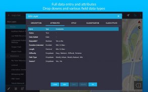
- ပိုမြန်ဒေတာစုဆောင်းခြင်းများအတွက်ပုံစံများကိုဆင်း Drop
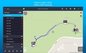
- အော့ဖ်လိုင်း GPS စနစ်ခြေရာခံခြင်း
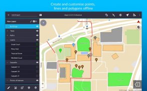
- တွင်မျက်နှာပြင်မှတ်ကိရိယာများ, ဆွဲစာသားကိုထည့်သင့်ရဲ့ဒေတာကိုကျော်ပုံစံမျိုးစုံကိုဖန်တီးရန်
- WMS / WFS & WMTS အချက်အလက်စာရင်းများအတွက်အပြည့်အဝ suite ကို Read and download
- အမှတ်, အနားနှင့် polylines
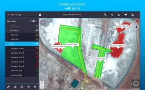
- Geofencing စွမ်းရည်သင်တစ်ဦးနယ်နိမိတ်ချိုးဖောက်ဘယ်တော့မှသေချာအောင်
- Overlay ကို Grid ဒေသများအကြားအတိအကျအကွာအဝေးကိုတွေ့မြင် coordinate
- မရရှိနိုင် On-screen ကိုမှတ်စာများနှင့်အတူလမ်းမြင်ကွင်း mode ကို
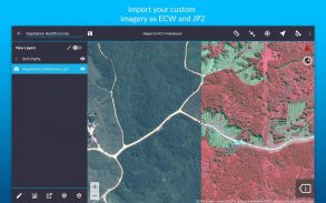
- သွင်းကုန်န့်အသတ်အရွယ်ဂြိုဟ်တု, ဝေဟင်, ဘူမိဗေဒဆိုင်ရာ, မြေမျက်နှာသွင်ပြင်, မြင့်နှင့် ECW အတွက်ပုံရိပ်နှင့် JP2 format နဲ့တခြားအမျိုးအစားများ
- ထိုသို့သော Shapefiles, JP2 နှင့် KML / KMZ အဖြစ်သွင်းကုန်နှင့်ပို့ကုန်လူကြိုက်များ GIS ကို formats
- ထိုသို့သော Google Drive ကိုအဖြစ်ရေပန်းစားသောမိုဃ်းတိမ်သိုလှောင်မှုအကြားသင့်ရဲ့ဒေတာကိုမျှဝေပါ
ကျွန်ုပ်တို့၏ clients များအပါအဝင် In-လယ်ကွင်းအလုပ်များကိုအကွာအဝေးဘို့ငါတို့အော့ဖ်လိုင်း GIS app ကိုအသုံးပြုခဲ့ကြပြီ
- ဖျော်ဖြေမှုမြေပုံ
- မြေတိုင်းထွာ
- သဘာဝပေါက်ပင်စီမံခန့်ခွဲမှု
- သစ်တောရေးရာစီမံကိန်းရေးဆွဲခြင်း
- ပတ်ဝန်းကျင်ထိန်းသိမ်းရေးစီမံခန့်ခွဲမှု
- ဆူပူမှုအစီရင်ခံ
- မိုင်းစီမံခန့်ခွဲမှု
- လယ်ယာမြေပုံ
- Utility ကိုမြေပုံ
- အစိုးရစီမံကိန်းရေးဆွဲခြင်း
- ပိုင်ဆိုင်မှုဆိုင်ရာစီမံခန့်ခွဲခြင်း
အင်တာနက်စိုးရိမ်, အခုတော့ဒီကြီးမားတဲ့ပစ္စည်းကိရိယာများနှင့်အတိတ်ကာလတိဒေတာ Leave နှင့် Mappt ™နှင့်အတူဒေတာစုဆောင်းခြင်း၏တစ်ဦးထက်ပိုထိရောက်အနာဂတ်ခံစားရသည်။
*** မှတ်ချက်: သင် 120 မိနစ်ရုံးတင်စစ်ဆေး Mappt ™အခမဲ့ဖြစ်ကြသည်။ ဤအချိန်တက်သည်နှင့်တစ်ပြိုင်နက်, သင်သည်အခြား 120 မိနစ် 8 နာရီစောင့်ဆိုင်း, ဒါမှမဟုတ်အပြည့်အဝလုပ်ဆောင်နိုင်စွမ်းကိုသော့ဖွင့်ဖို့အတွက်အမေရိကန် $ 29 ကနေလစဉ်လိုင်စင်ယ်ယူနိုင်ပါသည်ဖြစ်စေ။ features နဲ့လိုင်စင်အလွှာအကြောင်းပိုမိုသိရှိလိုပါက, www.mappt.com.au/pricing.*** သွားရောက်ကြည့်ရှုကျေးဇူးပြုပြီး
Mappt: GIS Data Collection - ဗားရွင္း 3.14.0
(22-01-2025)Mappt: GIS Data Collection - APK သတင္းအခ်က္အလက္
APK ဗားရွင္း: 3.14.0package: au.com.mapptMappt: GIS Data Collection ၏ ေနာက္ဆုံးဗားရွင္း
အျခား ဗားရွင္းမ်ား


က႑တူအက္ပ္မ်ား

သင္ႏွစ္သက္ႏိုင္သည္မ်ားမွာ...


